|
|
Home Page |
|
|
Welcome & Bio |
|
|
A Sample Weather Map |
|
|
The ONLINE BOOK:
SINGER'S LOCK: The Revolution in the Understanding of Weather Download the PDF version 54mb |
|
|
The Bible of Weather Forecasting |
All rights Reserved
Copyright © 1997 by Singer Press
| SAMPLE CHART
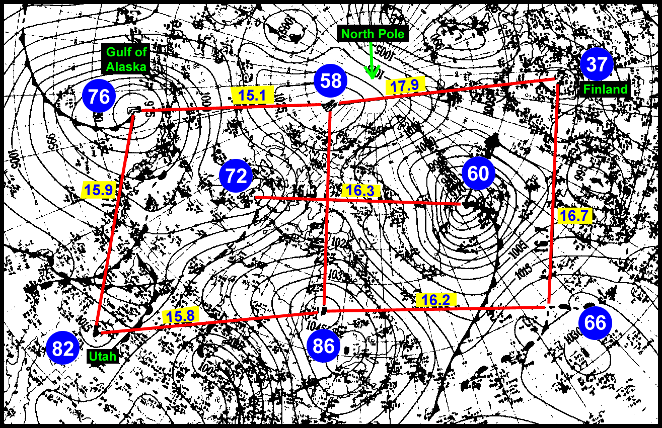
Structure of a Rapidly The structure shown in Chart #64A (see below) was "hastily" put together by the atmosphere in the Northern Hemisphere, because it certainly wasn't present the day before. This chart is a further explanation of the 7th of December 1950, the day chosen for detailed analysis in my book.
This is the first time this structure has been recognized and interpreted. The centers of the eight highs and lows of this moving formation are clearly defined. We have a reliable example. They are identified by a number near their center. Lines are drawn to join these vortexes. Let's start with the easy pickings first. The great circle distance between #76 and #82 is 1777.50 nautical miles (n.m.); between #82 (in southeastern Utah) and #86 is 1777.5 miles; and between #86 and #58 is 1788.75 miles. So far, so good—in fact quite remarkable that the distances between the three highs and one low are practically identical. Except for one flaw, the distance between #58 and #76 is 1698.75 miles. So we don't have a "purrfect" square. (We should not forget that this is an almost perfect spherical square on the earth's surface. See Chapter 3 for the meaning of a straight line on a polar stereographic map.) But wait, we are not at the end of this story. There is another attached square-like formation formed by #86, #66, #37, and #58. This group is close to being a square with sides of 1822.5, 1833.75, 1878.75, and a wild one at 2013.75. Not a bad combination, since this second "square" exists next to the first "square"--what we see becomes a little more impressive. Especially when we can see that two of the legs of this second square-like formation are slightly more than 16 ru, as compared with the legs of the first square, with slightly less than 16 ru. Are these two squarish configurations oscillating back and forth between each other as complete units across 16 ru? If you recall from 41.0.0, that a structure is stable only-when the distances between its parts can be expressed in whole number ru, not fractional ru. This point is, nevertheless, only a side issue in this particular discussion. Let us turn to the quadruplet formation of #58, #86, #72, and #60. We note that the center of low #72 is occupying a relatively similar position inside its square as compared to the center of low 60 in its square. Hmm.... A line drawn from #72 to #60 crosses at a perfect 90° to a line drawn from #68 to #86. An extra surprise is the distance of 1833.75 miles between #72 and #60. The leg from #76 to #58 is shorter than the other members of its square, while the leg from #58 to #37 (in Finland) is longer than the members of its square. These slightly distorted squares are disconcerting to any sense of architectural neatness and balance. There is some consolation that the short leg is connected to the long leg in almost a straight line. It almost seems as if these two legs were working together, what one lost, the other gained. That is interesting, but it still leaves us hanging with an unanswered question. Why? Low #76 (in Gulf of Alaska) and low #60 (slightly east of Greenland) are the most energetic of the gang of eight vortexes. The center of low #16 moved 60-100 miles by the next day. (This small move was hard to show on the map, so it was not entered.) The center of low #60, however, moved in the next 24 hours to the tip of the arrow (east of Iceland). Low #60 was the wild one. It was like a gorilla in a paper bag. Or like a bobcat in a purse. To start with, it was huge at the time of the map. #60 hogged the entire second square. and pressed against high #58 preventing that high from reaching equilibrium with #76. The resulting gap was a below normal 1698.75 miles at map time. Vortex #37 was already fleeing from #60 at the time of this map. Low #60 was in the process of helping to breakup that old gang of digital eight at the time of this map! Now we can understand (with low #37 taking off like a scared rabbit) why the leg from #58 to #37 was oversize and the leg from #66 to #37 was shortened. The subtle differences in the lengths of the legs of the pattern in Chart #64A gives insight into the precise nature of vortex movement. All rights Reserved |